


The soils
The
study
of
the
soils
of
the
Delta
is
carried
out
on
the
basis
of
the
textures
recorded
on
the
169
sites
sampled
to
assess
vegetation
and
ecological
parameters.
Soil
texture
measurements
carried
out
by
Pierre
Hiernaux
estimate
the
mass
contribution
of
clays
(between
0
and
20
µ),
loams
(between
20
and
50
µ)
and
sands
(between
50
µ
and
2
mm)
for
five
soil
depth
s
:
[0-6
cm],
[6-12
cm],
[12-25
cm],
[25-50
cm],
[50-100
cm].
These
data
have
been
simplified
by
grouping
soil
depths
in
two
levels:
(HOR1)
from
0
to
25
cm
and
(HOR2)
from
25
to
100
cm.
The
texture
of
each
level
is
assessed
by
the
arithmetic
mean
of
the
mass
contribution
of
clays,
silts
and
sands
of
each
component
layer
.
The
grouping
of
the
three
top
layers
is
justified
by
the
fact
that,
on
the
one
hand,
the
particle
sizes
of
the
first
two
layers
(0-6
cm)
and
(6
-
12
cm)
do
not
generally
differ
and
that,
on
the
other
hand,
the
differences
with
the
third
layer
(12
-
25
cm)
are
relatively
unmarked.
This
grouping
is
also
justified
by
the
root
system
of
most
aquatic
plants
in
the
Delta,
which
generally
does
not
exceed
25
cm
in
depth.
The
grouping
of
the
two
deeper
levels
is
supported
by
the
large
similarity
of
texture in the two component layers.
The
soil
texture
of
vegetation
mosaics
is
assessed
by
averaging
the
clay,
loam
and
sand
contribution
of
soil
supporting
each
plant association component, for HOR1 and HOR2.
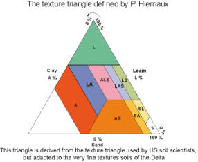
The
texture
triangle
was
defined
by
Pierre
Hiernaux.
It
is
derived
from
the
texture
triangle
used
by
US
soil
scientists,
but
adapted to the very fine textures soils of the Delta.
The
soils
of
the
Delta
have
been
classified
into
9
classes,
according
to
their
textures
,
and
numbered
from
0
to
9
in
the
databases:
[0
-
Sandy
soil,
denoted
S],
[1-
Sandy-loamy,
denoted
SL],
[2-
Loamy-sandy,
denoted
LS],
[3-
Sandy-clayed,
denoted
SA],
[4-Loamy-clayed-sandy,
denoted
LAS],
[5-
Clayed-loamy-sandy,
denoted
ALS],
[6-Loamy,
denoted
L],
[7-
Clayed-sandy,
denoted AS], [8 Loamy-clayed, denoted LA] and [9- Clayed, denoted A].
The
soils
of
the
Inner
Niger
Delta
are
mostly
fine
textured
soils,
heavily
loaded
with
loams
and
clays.
Two
main
categories
dominate
the
soils
of
the
alluvial
basin:
the
LA
–
Loamy-clayed
–
and
ALS
–
clayed-loamy-sandy
-
formations.
LA-type
soils
like
those
of
the
“
burgu
”
vegetation
contain
45
to
50%
of
loam,
more
than
30%
of
clay
and
less
than
20%
of
sand.
ALS-type
soils
are
also
heavily
loaded
with
loam
(more
than
45%)
but
contain
less
clay
(about
20%)
and
more
sand
(25
to
35%).
Sandy
clay
soils
only
come
in
third
position
with
sand
contributions
exceeding
50%
and
rising
up
to
80%.
They
are
mostly
found
on
the
“
togge
”,
unflooded
lands
in
the
Delta.
Table
3
shows
the
relationship
between
plant
associations
and
soil
types.
Among
the
plant
associations
supporting
deep
flood,
OP
is
related
to
the
most
clayed
soils,
followed
by
“
burgu
”
BP
and
B.
The
link
between
these
vegetation
associations
and
fine
textured
soils
is
explained
by
the
edaphic
characteristics
of
the
herbaceous
plants
that
develop
in
basins
or
plains
flooded
by
still
waters
and
also
by
the
filter
function
of
the
vegetation,
since
Oryza
longistaminata
,
like
Echinochloa
stagnina,
trap
sediments.
In
contrast,
VB,
the
deep
Vetiveria
savanna,
grows
where
the
stream
current
is
stronger.
Its
erect
tufts
filter
much
less
sediment
and
trap
more sand.
Table 3 : Plant associations per soil texture type (top/deep) and depth of flooding
Table 1 : Main types of Horizons
Download
Soil _data.rar
Table 2


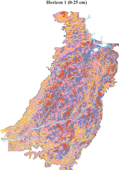


Distribution of the main types of soils in the Delta : Maps and table 2
