


Map 3
Map 4
Map 5

Map 6
Flora
According
to
the
survey
carried
out
by
P.
Hiernaux
and
L.
Diarra,
the
flora
of
the
inland
Delta
contains
52
woody
species
and
137
herbaceous
species.
The
taxonomy
of
species
is
taken
from
the
flora
by
Hutchinson
&
J.M.
Dalziel:
Flora
of
West
Tropical
Africa
(2nd
edition),
Keay,
R.W.J.
&
Hepper,
F.N.
(eds),
Vol.
1-3.
The
flora
of
the
inland
Delta
is
poor
(189
species),
even
compared
to
that
of
the
surrounding
Sahelian
lands,
which
is
characteristic
of
flooded
lands.
By
way
of
comparison,
the
Gourma
region
in
the
Niger
loop
has
about
350
species.
The
characterization
of
the
floristic
composition
of
each
plant
association
combines
two
notions:
that
of
indicator
value
and
that
of
abundance-dominance
of
species.
The
indicator
value
of
the
species
is
indicated
by
probability
thresholds
of
the
presence
of
the
species
within
a
100
m²
plot
selected
in
the
plant
association.
The
relevant
thresholds
and
corresponding
codes
are
the
same
as
for
the
ecological
profiles
and
correspond
to
those
indicated
in
the
section
dealing
with
the
data
processing.
The
abundance-dominance
is
indicated
independently
by
the
distinction
of
three
categories
of
species:
the
dominant,
accompanying
and
occasional
species.
It
is
proposed
to
ascribe
to
these
categories
a
contribution
of
respectively
80%,
15%
and
5%
to
the
production
of
the
herbaceous
mass.
These
arbitrary
rates
are
to
be
shared
between
the
species
listed
in
each
category.
In
other
words
(Table
2),
the
floristic
form
of
a
plant
association
comprises
a
list
of
species,
each
species
being
characterized
by
its
indicator
sign
(0,
•
,+,
++,
+++)
and
an
indication
of
abundance-dominance
status
in
the
association
as
coded
according
to
Table
1,
translated
into a quantitative contribution of the species to herbage mass and production.
T
able 1 :
Abundance-dominance status
of the species Table 2 : profile card for B bourgoutière with Echinochloa stagnina

The
plant
association
coded
B
only
comprises
herbaceous
plants.
The
dominant
herbaceous
species
of
a
plant
association
tally
80%
of
the
herbaceous
mass,
the
rule
of
equitable
distribution
prevailing
between
species
of
the
same
status,
two
in
this
case,
40%
for
Echinochloa
stagnina
and
40%
for
Vossia
cuspidata
.
Herbaceous
companions
account
for
15%
of
the
herbaceous
mass,
and
occasional
herbaceous
plants
account
for
the
remaining
5%.
Again,
the
rule
of
equal
distribution
prevails
between
species
of
the
same
category.
When
a
plant
association
comprises
herbaceous
and
woody
plants,
the
same
distribution
rules
apply
separately
to
the 100% herbaceous mass and the 100% leaf mass of the woody plants.
The
layer
FLORE1
keeps
the
Delta
vegetation
units
(VEG4
layer)
but
associates
them
to
a
data
table
listing
the
189
plant
species
(137
herbaceous
and
52
ligneous)
present
in
the
Delta.
The
structure
of
the
data
table
is
therefore
imposed
and
has
190
columns
-
or
fields
-
(1
"acronym"
field
and
189
"species"
fields)
by
120
lines
(1
line
for
each
vegetation
type
listed
in
the
layer
VEG4).
For
each
plant
species,
its
contribution
to
the
herbaceous
mass
or
the
woody
plant
foliage
mass
is
indicated
for
each
vegetation
type.The
absence
of a particular species is coded "0".
In
order
to
facilitate
the
creation
of
the
table,
the
fields
of
the
137
herbaceous
species
listed
in
alphabetical
order
have
been
referred
to
as
"her_1"
to
"her_137",
the
woody
species
being
referred
to
as
"lig_1"
to
"lig_52".
A
table
in
the
annex
indicates
the
correspondence between the name of the field and the name of the plant species.
Working
from
FLORE1,
it
is
therefore
possible
to
map
the
spatial
distribution
of
each
plant
species
present
in
the
Delta,
either
in
terms of "presence/absence" or by means of queries related to rates of participation to the plant mass in each association.
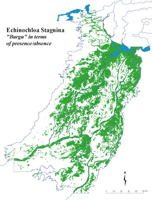
Map
1
represents
Echinochloa
stagnina
-
the
“burgu”
-
according
to
its
presence
/
absence.
Map
2
depicts
Echinochloa
stagnina
based
on
its
participation
to
the
herbaceous
mass
of
each
unit,
giving
a
very
different
picture:
the
Delta
“
bourgoutieres”
correspond
only to the areas where
Echinochloa stagnina
is the dominant species.
The
abundance
of
one
species
marks
the
vegetation
units
characterized
by
a
single
plant
association
in
which
that
species
dominates
–“
bourgoutière”
,
wild
rice,
Vetiver
and
Eragrostis
savannas
-
but
those
plants
are
also
present
in
multiple
mosaics.
Thus,
Echinochloa
stagnina
is
dominant
in
the
bourgoutière
B
and
in
the
deep
bourgoutière
BP,
but
it
also
contributes
with
various
mass
shares to nearly thirty vegetation types, as shown by the comparison of maps 1 and 2.
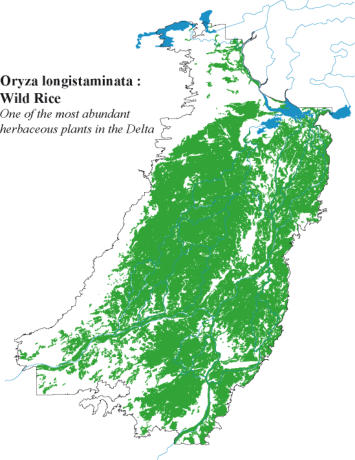
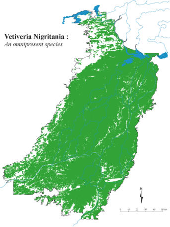
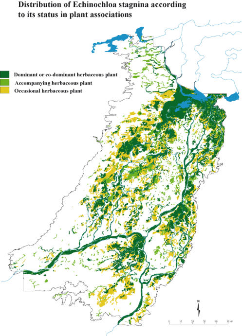
Maps
3
to
5
present
the
spatial
distribution
of
very
common
species
in
flooded
or
dry
vegetation
types.
On
the
contrary,
map
6
presents the distribution of a species that is an environment marker.
Map 2
The layer «FLORE1»
Map 1
The
three
maps
3
to
5
show
the
spatial
distribution
of
the
presence
of
three
very
common
herbaceous
species
in
the
flooded
and
dry
environment.
Vetivera
nigritana
(her_134)
is
ubiquitous
as
soon
as
there
is
flooding.
Referring
to
a
level
dominated
by
Vetivera
nigritana,
as
found
in
part
of
the
literature
devoted
to
the
Delta
vegetation,
is
therefore
a
contradiction:
not
only
do
the
various
Vetiver
savannas
occupy
flood
levels
ranging
from
level
3
to
level
6,
but
Vetivera
nigritana
is
also
found
in
the
deepest
flood
level
-
level
7
-
in
the
PAK
association
and
in
the
shallowest
flood
level
-
level
2
-
in
the
ZB
association,
as
an
accompanying
herbaceous
in
both
cases.
Oryza
longistaminata
(her_93)
is
very
abundant
in
the
flooded
plains
of
the
Delta
and
marks well the areas with regular average flooding.
In
contrast
to
Oryza
longistaminata
,
the
association
of
Piliostigna
reticulatum
(lig_39),
Acacia
seyal
(lig_10)
and
Acacia
raddiana
(lig_8)
characterizes
the
dry
"wooded"
Delta,
mainly
located
on
the
margins
and
on
the
hillocks,
the
Togge
and
the
Peroudji
,
where
the
villages
are
preferentially
located
as
well
as
the
Bille
,
the
pastoral
camps
where
the
herds
rest
when
they
are
not
grazing
in
the
flooded
plains
of
the
"grassy"
Delta,
which
is
exploited
by
fishermen,
rice
farmers
and
pastoralists.
There
are,
however, a few exceptions of woody plants growing in flooded plains such as
Mimosa pigra
and
Acacia kirkii
.
Flore_1.gdb.rar
Flora annexes

Download


Download
Map 7
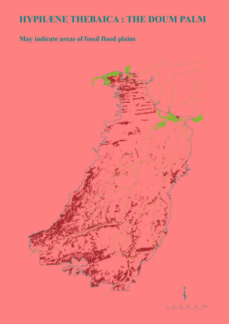
The
last
species
mapped
is
a
marker
of
"environments".
Hyphaene
thebaica
(lig_32),
the
doum
palm,
has
the
particularity
of
being
born
"with
its
feet
in
the
water",
i.e.
in
more
or
less
flooded
spaces.
In
particular,
it
is
a
tree
characteristic
of
the
borders
of
certain Sahelian backwaters (Map 6).
In
the
adult
stage,
however,
it
can
look
for
water
very
deep
in
the
water
table.
It
is
a
tree
that
lives
old
–
more
than
300
years
–
and
it
is
now
located
in
places
that
are
still
flooded
today
or,
on
the
contrary,
in
places
that
are
never
affected
by
flooding
again
but
that
could
have
been
one,
two
or
three
centuries
ago.
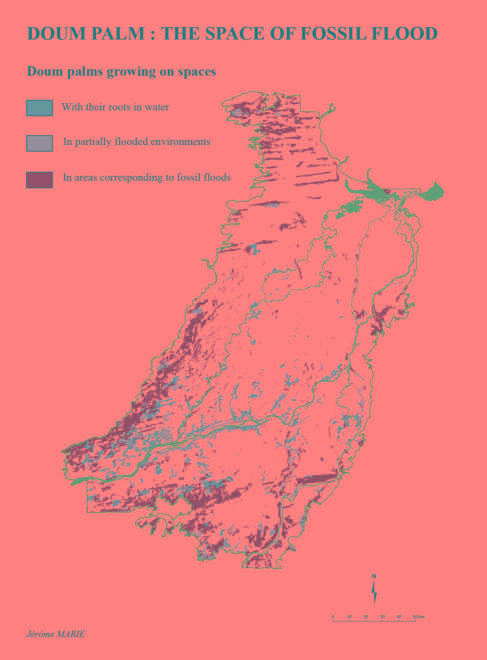
Comparing
the
distribution
of
the
doum
palm
with
the
limits
of
the
current
flood
allows
us
to
identify
areas
of
"fossil
flooding".
Thus,
the
differentiation
between
the
current
limits
of
the
flooding
by
the
reference
flood
of
6.60
m
and
the
Hyphaene
thebaica
right-of-way
(map
7)
suggests
areas
not
flooded
(in
green
on
the
map)
by
the
reference
flood
but
likely
to
have
been
flooded
by
exceptionally
strong
floods
(between
660
cm
and
740
cm
on
the
scale
of
Mopti) as was the case in the 1950s or by equivalent floods or stronger 200 or 300 years ago.
On
Map
7,
doum
palms
growing
on
regularly
flooded
areas
occupy
294
plots
for
a
total
area
of
43,998
ha.
Those
growing
on
partially
flooded
areas
occupy
252
plots
covering
36,878
ha,
while
doum
palms
now
located
on
fossil
flood
areas
total
2231
plots
for
167,180
ha.
In
simplified
terms,
the
distribution
of
doum
palms
between
those
growing
in
water
and
those
located
in
the
territory of ancient floods now fossil or rarely reached is of the order of 1/3 - 2/3.