The
model
of
the
area’s
natural
environment
is
based
on
the
Niger
Delta
rangeland
map
produced
by
the
CIPEA-IER
/
ODEM
team
as
explained
in
the
history
of
the
project.
It
covers
the
plains
of
the
Niger
basin
from
Ké
Macina
(on
the
Niger
River)
and
Baramandougou
(on
the
Bani
River)
upstream
to
lake
Débo
downstream,
including
a
fraction
of
Farimaké
to
the
northwest
of
Lake
Débo,
a
total
area
covering
slightly
over
22,000
km².
This
map,
together
with
the
accompanying
studies,
was
to
be
used
for
a
regional
development
plan
with
the
creation
of
pastoralists'
or
agro-pastoralists'
associations.
This
perspective
determined
the
level
of
precision
sought
in
the
definition
of
map
themes,
the
scale
of
surveys
and
map
restitution,
i.e.
1:50
000.
This
is
not
a
cadastral
scale
but
one
that
is
detailed
enough
(the
area
of
the
smallest
mapped
units
is
about
1
ha)
to
model
the
regional
ecosystem,
an
essential
step
forward
in
the
process
leading
to
a
better
understanding
of
spatial
issues
for
the
use
and
appropriation
of
resources
in
the Delta.
1 - Field surveys
We
are
giving
here
only
the
minimum
number
of
indications
to
understand
the
methodology
we
implemented;
for
further
details,
the
reader
will
refer
to
the
work
of
Hiernaux
et
al.
(cited
in
the
bibliography).
The
assessment
of
the
fodder
resources
of
the
Delta
is
established
on
the
basis
of
a
phyto-ecological
study.
The
fodder
productivity,
floristic
composition,
sensitivity
to
grazing,
etc.,
are
reported
in
relation
to
about
twenty
types
of
rangelands
defined
in
a
prior
phyto-ecological
study.
The
rangeland
types
are
defined
both
by
the
characteristics
of
their
vegetation
–
floristic
composition
and
bio-morphological
structure
–
and
by
those
of
the
environment– topographic and geomorphological positions, soil textures, flooding regime, mode of pastoral exploitation...
The
phyto-ecological
analysis
was
carried
out
on
169
sites
of
100
m²
each,
127
located
in
the
flood
plains,
8
in
the
irrigated
rice
fields
of
the
Office
du
Niger
and
34
others
in
the
unflooded
uplands
of
the
Delta.
The
implementation
of
a
methodical
and
simultaneous
survey
of
the
characteristics
of
the
vegetation
and
the
environment
is
largely
inspired
by
the
method
developed
by
CNRS researchers from the CEPE Louis Emberger Laboratory (M. Godron
et al
., 1968, Ph.Daget
et al
. 1970).
In
addition
to
the
plant
mass
measurements
accompanying
each
phyto-ecological
survey,
twelve
sites
were
devoted
to
vegetation
production
measures
(a
mesh
enclosure
of
1000
to
1500
m²
was
set
for
each
site).
Measurements
and
treatments
were
carried
out
within the enclosures, therefore on rangeland protected from grazing.
The main measurements made within the enclosures were as follows:
seasonal and inter-annual changes of standing mass and production when protected from grazing,
effect of mowing and burning practiced at earlier or later stages, on grass regrowth,
effect of several repetitive mowing regimes on the production of regrowth in the dry season,
effect of several repetitive mowing regimes following initial burning on the production of regrowth in the dry season,
trials in hay making, in terms of cutting period and mode of conservation.
In
addition,
in
three
of
these
twelve
sites,
a
piece
of
rangeland
of
several
hectares
was
identified
and
monitored.
The
systematic
monitoring
of
livestock
numbers
and
of
the
duration
of
their
presence
within
this
rangeland
was
used
to
estimate
seasonal
stocking
rates.The
grass
mass
was
monitored
throughout
the
dry
season
in
the
grazed
rangeland
and
also
inside
mobile
cages
displaced
every
15 days to measure the regrowth of the grass under grazing.
2 - Data processing
As
for
the
survey
method,
the
analysis
of
the
data
uses
the
calculation
procedure
recommended
by
the
researchers
of
the
Center
of
Phytosociological
and
Ecological
Studies
Louis
Emberger
(CNRS
Montpellier)
where
the
calculations
were
carried
out.
Two
approaches
were
combined:
one
more
analytical,
with
the
establishment
of
the
ecological
profiles
of
the
species
for
the
main
ecological
variables,
the
other
more
synthetic
for
the
factorial
analyses
of
the
correspondences
which
are
carried
out
in
the
"species-
site" and the "species-states of variables" matrices.
For
each
plant
association,
flora,
ecology,
annual
and
seasonal
vegetation
and
fodder
production
are
characterized
on
the
basis
of
systematic
information
collected
in
169
sites
(393
taxa
and
119
ecological
variables).
Statistical
analyses
of
these
data
established
the
floristic
and
ecological
profiles
of
each
plant
combination.
These
are
so-called
'indexed
ecological
profiles’,
in
which
the
indication
for
each
class
of
the
variable
or
taxon
considered
constitutes
a
threshold
of
probability
of
presence
or
absence
(of
the
plant
association
in
the
situation
corresponding
to
a
class
of
the
variable,
or
of
the
species
in
the
plant
association).
The
method
known
as
"indexed
ecological
profiles"
is
described
in
a
seminal
article
co-authored
by
B.
Gauthier,
M.
Godron,
P.
Hiernaux
and
J.
Lepart,
"
A
complementary type of ecological profile
, Canadian Botanical Association, 1977, Vol 55, pp. 2859-2865. "
It
consists
in
"analyzing
a
collection
of
phyto-ecological
surveys
taking
into
account
the
presence
of
plant
species
and
a
number
of
variables
characterizing
the
environment".
Concretely,
a
test
assesses
the
sensitivity
of
the
plant
species,
or
of
the
plant
combination
considered, to the state of the variable. Five cases of sensitivity are recorded and coded in the database.
Table
1:
Codes
representing
the
intensity
of
species/plant
association
profile
linkages
or
plant
association/status
of
variables.


The
identification
of
plant
combinations
and
field
checks
were
carried
out
between
September
1979
and
September
1982.
27
elementary
plant
combinations
were
recognized,
17
of
which
were
in
the
flood
plains
and
the
Delta
rice
fields,
3
in
the
northern
lake plains and 7 on islands, banks and high plains.
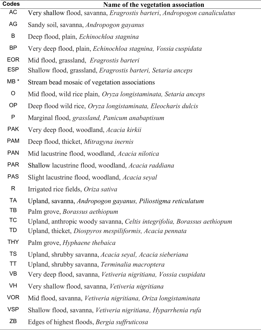
*
MB
The
mosaic
of
the
banks
is
not,
strictly
speaking,
a
plant
combination,
but
a
complex
mosaic.
It
provides
a
"shortcut"
for
different
flooded
formations
(VB,
B,
O,
VOR,
VSP,
VH,
AG,
ZB).
It
is
located
on
the
edge
of
the
River’s
minor
bed,
on
the
spread
of
narrow
levees
and
channels
which
occupy
the
major
bed
of
the
Niger,
the
Bani
and
their
main
tributaries.
Its
main
characteristics
are
the
subject
of
a
specific
sheet,
but
are
not
determined by calculation like other mosaics.
Photo-interpretation and mapping
The
mapping
was
done
on
the
basis
of
a
photo-interpretation
of
the
cover
75
MAL
32/500
23x23
cm
panchromatic
and
IRC
–
infra-red
color
plates
-
1:50
000
complemented
locally
by
covers
74
MAL
20/500
for
the
south-west
and
70/71
AO
891/500
for
the
eastern
bank.
In
the
course
of
the
initial
surveys,
the
correspondence
between
the
nature
of
the
vegetation
type
and
that
of
the
topo-
geomorphological
environment
was
established
on
a
case-by-case
basis,
on
the
basis
of
their
aspects
in
aerial
photographs.
Mark
Haywood
then
proceeded
with
the
photo-interpretation
under
stereoscope
with
very
high
magnification,
delimitating
the
recognized
vegetation
types.
The
boundaries
were
drawn
by
hand
on
the
topographic
map
of
the
National
Geographic
Institute
(I.G.N.)
and
the
OICMA
map,
enlarged
by
the
kilometric
grid
method.
The
field
checks
were
carried
out
by
Pierre
Hiernaux,
Lassine
Diarra
and
Mark
Haywood.
In
this
vegetation
map,
Mark
Haywood
refers
only
to
the
vegetation
types,
without
separating
the
cultivated
areas
whose
location
and
extent
vary
from
year
to
year.
The
cultivated
areas
have
been
mapped
in
work
published
separately.
Indeed,
on
aerial
photos,
particularly
infrared
ones,
one
can
"read"
the
vegetation
types
under
the
cultivated
plots
which,
even
if
they
are
used
for
rice-
crops,
are
a
system
of
temporary
cultivation
alternating
with
fallows.
This
particularity
will
be
very
valuable
to
determine
which
vegetation
types
have
been
cleared
at
various
times.
However,
such
readings
are
not
possible
in
the
case
of
controlled
irrigated
schemes
from
which
all
traces
of
previous
vegetation
types
have
disappeared.
Such
is
the
case
of
the
Office
du
Niger
schemes
which
are
coded
R,
like
a
particular
plant
association.
BP,
B
and
VB
constitute
very
deep,
plain
“bourgoutières”
and
“Low
Vetiver
stands”,
PAK
corresponds
to
very
deep
Vetiver
stands
with
Acacia
Kirkii
and
PAM
to
channels
and
low
plains
with
Mitragina
inernis
.
OP,
O
represent
deep
and
plain
wild
rice,
VOR
and
EOR,
deep
Vetiver
and
Eragrostis
savannas,
VSP
and
ESP,
medium
Vetiver
and
Eragrostis
savannas,
VH
and
AC
the
high
plain
Vetiver
and
Eragrostis
savannas,
P
and
ZB
the
Panicaies
and
flood
edge
savannas.
AG
is
a
shrubby
savanna
weakly
flooded
with
Andropogon
gayanus
and
the
plant
combinations
ranging
from
TA
to
TT
are
"dry"
formations
that
normally
are
not
affected
by
flooding.
They
are
located
on
the
dry
margins
and
on
the
"
togge
”
(sg.
toggere
),
the
Fulani
name
for
the
never-flooded
mounds
in
the
Delta.
PAN,
PAS,
PAR
are
woody
savannas
extending
in
the
plains
where
the
flood
is
very
irregular
and
related
to
local
run-offs
during
the
rainy
season
and
then,
at
the
end
of
the
year,
to
delayed
river
flooding
reverting
through
the
channels
toward
the
northern
lakes.
They
are
found
mainly
in
Farimaké.
A
map
unit
represents
one
of
the
27
elementary
plant
combinations
(28
with
the
mosaic
MB)
indicated
by
its
acronym
or,
more
often,
a
mosaic
of
two
elementary
types
representing
a
gradient
along
a
slope
or
small
ripples
of
land
that
reflect
small
but
significant
variations
in
flood
conditions
over
a
small
area.
In
some
cases,
photo-interpretation
would
have
made
it
possible
to
separate
the
constituent
types
from
the
mosaics,
but
the
small
size
of
the
units
would
have
rendered
the
map
very
difficult
to
read.
In
the
rest
of
the
text,
the
term
"vegetation
type"
is
a
generic
term.
The
term
"plant
combination"
refers
to
the
27
elementary
plant
combinations
identified
by
Pierre
Hiernaux.
They
are
always
identified
by
an
acronym
consisting
of
one
to
three
letters,
as
shown
in
the
previous
table.
The
phrase
"vegetation
mosaic"
designates
a
composite
of
vegetation
types.
They
are
always
identified
by
an
acronym
that
is
itself
composite,
the
two
constituent
elements
of
which
are
separated
by
a
slash.
Thus
O/VOR
is
a
mosaic
whose
constituent
elements
are
the
plant
combination
O
and
VOR
. The methods for calculating these mosaics will be described in the section on vegetation databases.
Finally,
the
information
for
each
plant
combination
is
grouped
into
three
sections:
flora,
ecology
and
production.
These
three
sections
have
been
kept
in
the
database
architecture
and
correspond
to
a
collection
of
records
(pdf)
and
tables
which
are
freely
downloadable.
.
Table 2 : Codes and names of the twenty seven vegetation associations of the Inland Delta of the Niger


Field survey methods and data processing