


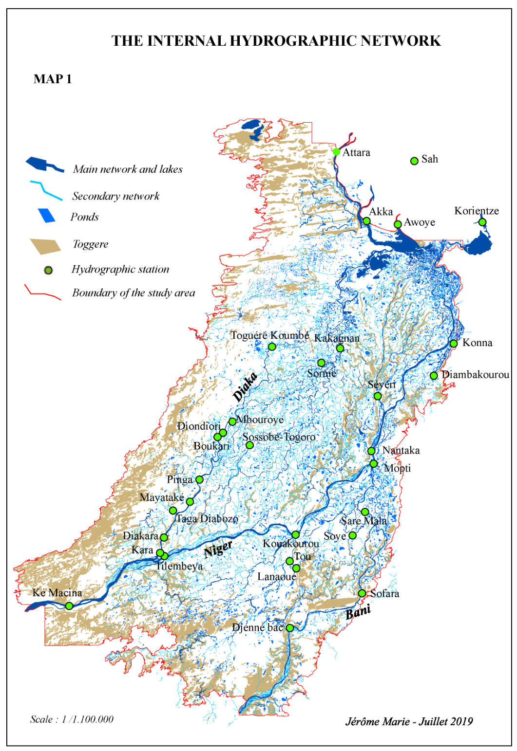
The internal hydrographic network of the Delta
The
hydrographic
network
within
the
Delta
was
first
mapped
from
the
1:
50,000
aerial
photo
coverage
in
order
to
allow
the
teams
in
charge
of
mapping
pastoral
territories,
livestock
tracks
and
camps
to
locate
themselves
in
the
field
(GPS
did
not
exist….).
This map is transcribed here as 6 separate ArcGis files stored in the GDB Hydro:
lim_delta1wgs: delineates the Delta
'
s flooded area (Farimaké excluded).
hydro_poly:
delineates
the
course
of
the
main
streams
of
the
network
(including
the
Niger
and
Bani
rivers,
the
Diaka
and
other main defluents) as polygons.
hydro_line: delineates the secondary streams as lines.
ponds: delineate the ponds within the Delta.
togge: delineate the never flooded uplands and rivers banks as polygons.
position_stations_wgs: locate the historical linminetric scales within the Delta.
This
hydrographic
network,
of
an
astonishing
complexity,
was
then
integrated
to
the
Digital
Elevation
Model
that
we
intend
to
build
from
the
vegetation
association
map,
the
derived
flood
depths,
the
topographical
survey
data
made
by
IGN
for
the
Mathematical Model of Niger River and from flood data.
The
«main
streams»
network
(hydro_poly)
comprises
229
polygons,
the
«secondary
streams»
network
is
7,698
km
long,
the
shortest
stream
measuring
57
m
while
the
longest
is
27
km
long.
These
elements
are
organized
into
a
multitude
of
local
networks
interconnecting
or
supplying
flood
water
to
the
multiple
basins
that
form
the
Inner
Delta.
In
addition
to
this
network,
there
are
8,824
ponds
of
largely
variable
areas.
The
majority
are
very
small,
consisting
of
a
simple
residual
trough
within
a
vegetation
unit.
The
largest (around 300), whose toponymy has been noted, have areas that can exceed 100 hectares each (403 ha for the largest).
The
map
presented
here
shows
the
different
elements
of
the
network.
In
October
a
map
and
the
ArcGis
base
showing
the
network
with
its
connections
and
hierarchies
will
be
made
available.
In
order
to
have
an
ArcGis
base
operating
only
with
polygons,
the
secondary
network,
which
initially
appeared
in
a
linear
mode
only,
has
been
replaced
with
polygons,
with
each
secondary arm of water being arbitrarily ascribed a width of 10 m.
Connecting
elements
that
belong
to
the
same
group
allows
us
to
establish
a
hierarchy
between
the
various
networks
(rank
1,
rank 2, etc...)
The
toponymy
of
the
main
arms
of
water
and
of
the
ponds
is
present
in
two
point
layers,
the
name
being
given
to
the
point
corresponding to the barycentre of the element in question.
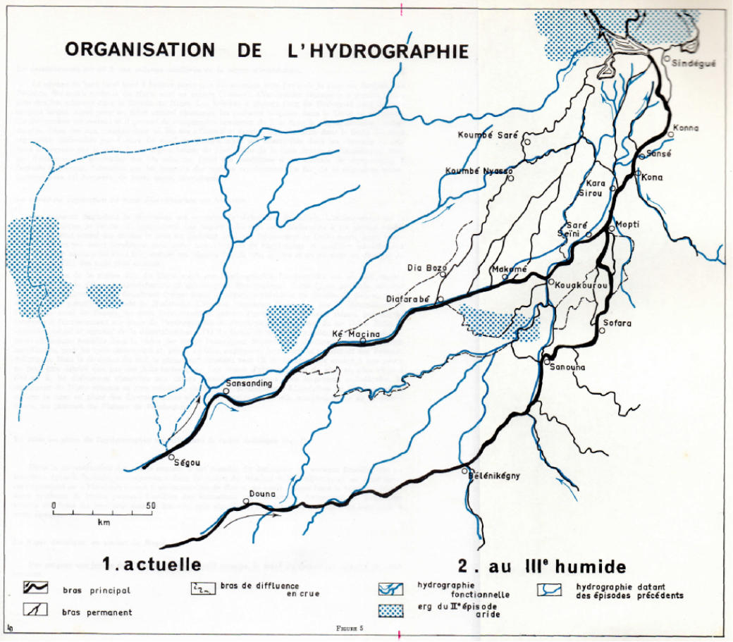
The
current
hydrographical
network
results
from
a
long-term
evolution
which
took
place
in
the
Tertiary
and
Quaternary
ages,
because
of
a
tectonic
shift
which
affected
the
Bandiagara
plateau
and
the
terminal
continental
that
constitutes
the
piedmont
plateau.
This
shift
caused
the
network
to
move
eastwards,
in
the
context
of
a
series
of
climate
alternations
(arid
vs.
humid
phases),
which
led
it
to
its
present
positioning.
Those
shifts
in
climate
as
applied
to
the
south
of
the
Sahara
and
the
Sahel
make
ice
ages/
regressing
seas/
dry stages coincide.
Jean
Gallais’s
study,
The
Inner
Delta
and
its
margins:
a
morphological
study
,
CNRS
publications,
1962,
from
which
map
n°2
is
derived, distinguishes different phases in the process:
At
the
end
of
the
Ogolian-Kanemian
era
(20000
to
12000
before
present),
there
appear
“two
ergs
with
an
eastern/western
direction
[...]
The
bigger
one
is
that
of
Niafunké:
it
stops
the
downstream
flow
and
keeps
the
waters
of
the
middle
part
of
the
Niger
river
within
an
immense
basin,
thus
creating
the
inner
Delta.
Further
south,
a
less
massive
erg,
that
of
Samaye-Djenné,
is
80
km
long
and
stops
the
waters
coming
from
the
Koutiala
plateau
in
the
area
that
is
now
the
Bani.
A
basin
which
today
takes
only
the
residual
shape
of
the
Pondori
then
used
to
reach
from
the
sandy
rise
of
the
Eastern
border
to
the
dunes
[...]
in
the
Western
one.”
(J.
Gallais,
1967, p.52).
During
the
Holocene
age,
the
next
humid
episode
(9300
to
6900
before
present),
referred
to
as
the
3
rd
Humid
on
the
map,
follows
the
building
of
the
Niafunké
erg.
It
is
believed
to
have
been
characterized
by
strong
rainfalls
(possibly
1.25
m
per
year?).
It
is
thought
to
have
resulted
in
the
creation
of
the
main
arms
of
today’s
“Dead
Delta”
and
Peru
Dialloubé,
with
a
flood
level
that
exceeds
today’s
level
by
5
meters.
Breaking
through
the
Samaye-Djenné
erg,
the
current
Inner
Delta
now
stands
as
a
unit
upstream
from the dune range at Niafunké
. (Ibid.)
After
a
short
dry
period,
the
next
humid
one
(5400
to
4000
before
present)
sees
the
subsidence
continue,
with
the
Niger
and
the
Bani
rivers
occupying
their
current
beds,
further
east.
The
gradually
increasing
dryness
of
the
climate
between
3500
and
1500
before present results in the contemporary levels of flooding.
MAP 2


Download
Hydro.gdb.rar
Maps 1&2.rar


Download