


Vegetal landscapes and hydrological basins
One
of
the
possible
uses
of
the
model
in
isolines
of
equal
depth
of
flood
consists
in
identifying
the
limits
of
large
vegetal
landscapes
units
within
the
Delta,
and
in
seeking
the
existence
of
hydrological
basins
appearing
as
closed
or
almost
closed
shapes at certain flood levels
1-The large hydrological basins
To
determine
the
main
large
hydrological
basins,
we
looked
at
contour
curves
with
closed
or
"almost
closed"
shapes
with
two
additional conditions:
-
at the level directly above, the contour curve is not closed
-
at lower levels contour curves are nested one inside the other.
One
of
the
remarkable
characteristics
of
these
basins
is
their
threshold
depth,
which
is
specific
to
each
basin.
The
basins
located
upstream
on
the
Niger
(Moura,
Koubaye,
Mopti-sud)
as
well
as
in
the
Bani-Niger
Mesopotamia
(Pondori,
Yongari-Mangari
and
Sebera)
start
to
appear
at
the
contour
curve
-
1.10
m,
i.e.
for
a
flood
of
5.50
m
at
the
Mopti
gauge.
The
Pondori
even
takes
shape
around
-0.90
m
and
appears
completely
isolated
at
-1.10
m.
The
three
basins
directly
dependent
on
Bani
and
Mopti-nord
have
a
threshold contour at -1.20 m.
The
basins
of
the
center
of
the
Delta,
Tenenkou
(-1.40
m),
Kakagnan
and
Kadial
(-1.60
m)
are
located
deeper
than
the
southern
basins.
Finally,
the
threshold
contour
for
Toggere
Koumbe
is
at
-2.00
m
and
the
Débo-Walado,
which
we
have
not
separated
from
the
Konna basin, has a threshold contour at -2.20 m.
These
differences
in
threshold
contours
between
basins
are
linked
to
the
morphology
of
the
Delta
and
result
from
the
tectonic
move
towards
the
north-east,
which
caused
all
channels
to
move
eastwards
and
resulted
in
the
Peroudji
channels
from
Ouro
Modi
to
Dialloubé
being
deserted
and
replaced
by
the
current
Niger
flow
through
Mopti
and
Konna.
This
explains
the
lower
subsidence
of
the
southern
part
of
the
Delta
floodplain,
which
is
accompanied
by
a
more
intense
alluvium
deposition,
perfectly
in
agreement
with
the
morphological
study
by
Jean
Gallais:
“
The
Inner
Niger
Delta
and
its
borders:
a
morphological
study
”,
(Memoirs
and
documents
of
the
CNRS,
vol.
3,
1967,
54
p.,
5
maps,
p
144)
which
described
the
southern
basins
as
"hanging
basins"
compared
to
those,
deeper,
of
the
center of the Delta and,
a fortiori
, that of Débo-Walado.
2 –The vegetal landscapes:
The thresholding of the Veg7k3 matrix also allows us to separate the vegetal landscapes of the Delta into major categories:
- the dry lands bordering the Delta and the large islands within the floodplain
- the high plains, shallowly flooded (between -0.0 m and -0.60 m)
- the moderately flooded plains and channels (between -0.60 m and -1.50 m)
- the deeply flooded plains and channels (= <-1.50m)
The
flood
depth
contours
oppose
the
floodplains
characterized
by
moderate-to-deep
flooding
of
plains
and
channels,
mainly
situated
along
the
Diaka,
and
those
characterized
by
shallow
floods,
mainly
located
in
the
south
(Diafarabé
region),
towards
the
upstream
limits
of
the
active
Delta.
In
the
south,
the
flooded
erg
of
Samaye
extends
towards
the
Pondori
and
Yongari-Mangari
basins,
which
it
contributes
to
separate.
The
erg
of
Femaye
further
extends
to
the
east,
forcing
the
Bani
river
to
bend
its
course.
The
high
plains
of
Soye,
north
of
Femaye,
contribute
to
clearly
separate
the
southern
basins
from
the
Bani-Niger
Mesopotamia.
Finally,
a
set
of
fossil
levees
form
uplands
along
an
SSW
-
NNE
alignment.
They
stretch
from
the
Moura
basin
to
the
south
of
Lake
Débo
and
testify
to
the
existence
of
a
former
course
of
the
Niger
which
is
now
fossilized.
This
helps
to
isolate
the
basins
in
the
west
of
the
Delta,
which,
from
Ténenkou
onwards,
organize
and
communicate
through
a
set
of
deep
flood
plains
finally
joining
the
Wallado-Débo.
These
deep
plains
do
not
exist
in
the
south,
and
are
almost
absent
in
the
east
at
Mopti
and
are
only
found
again
to
a
certain
extent
in
the
northeast,
near Konna.
Map 1 : The main inner Delta plant landscapes
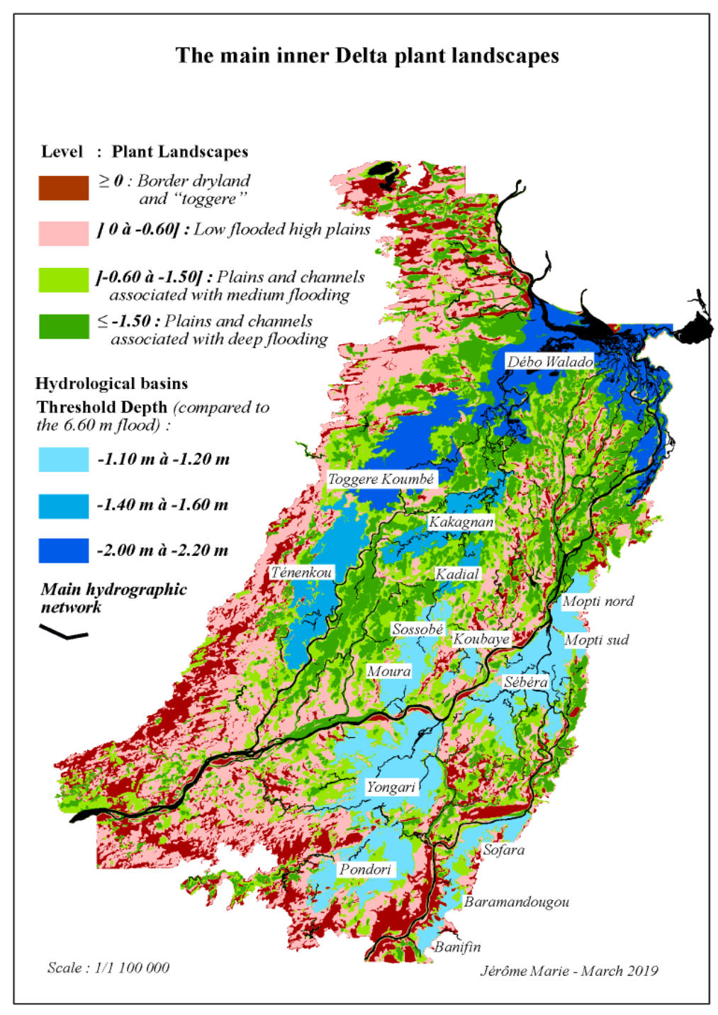


Table 1 : the main sixteen basins
Download
Landscape.rar